
A well-planned day on the water depends on more than the anchorage. If you’re preparing to anchor and swim at Cedar Point County Park, start with the practical details on shore: the park’s amenities and seasonal operations. Suffolk County Department of Parks, Recreation and Conservation describes the East Hampton park as spanning 607 acres.
The appeal is easy to imagine: time afloat, a refreshing swim, and a chance to take in the shoreline. To plan with confidence, though, it helps to know what facilities can shape your visit and how the operating season affects your timing.
This guide brings those details together, with a clear look at Cedar Point County Park’s amenities and seasonal information to consider when planning an anchor-and-swim outing. You’ll have a better sense of how to shape a relaxed day around the park and the water.
Key Takeaways
- Learn what to look for when identifying a suitable anchoring area near the park.
- Understand how to plan for swimming in relation to your boat and nearby activity on the water.
- See which boating-rule details matter when planning your route and time near Cedar Point.
- Recognize how changing water conditions can shape a more thoughtful swim and anchoring plan.
Where are the designated anchoring areas near Cedar Point County Park?
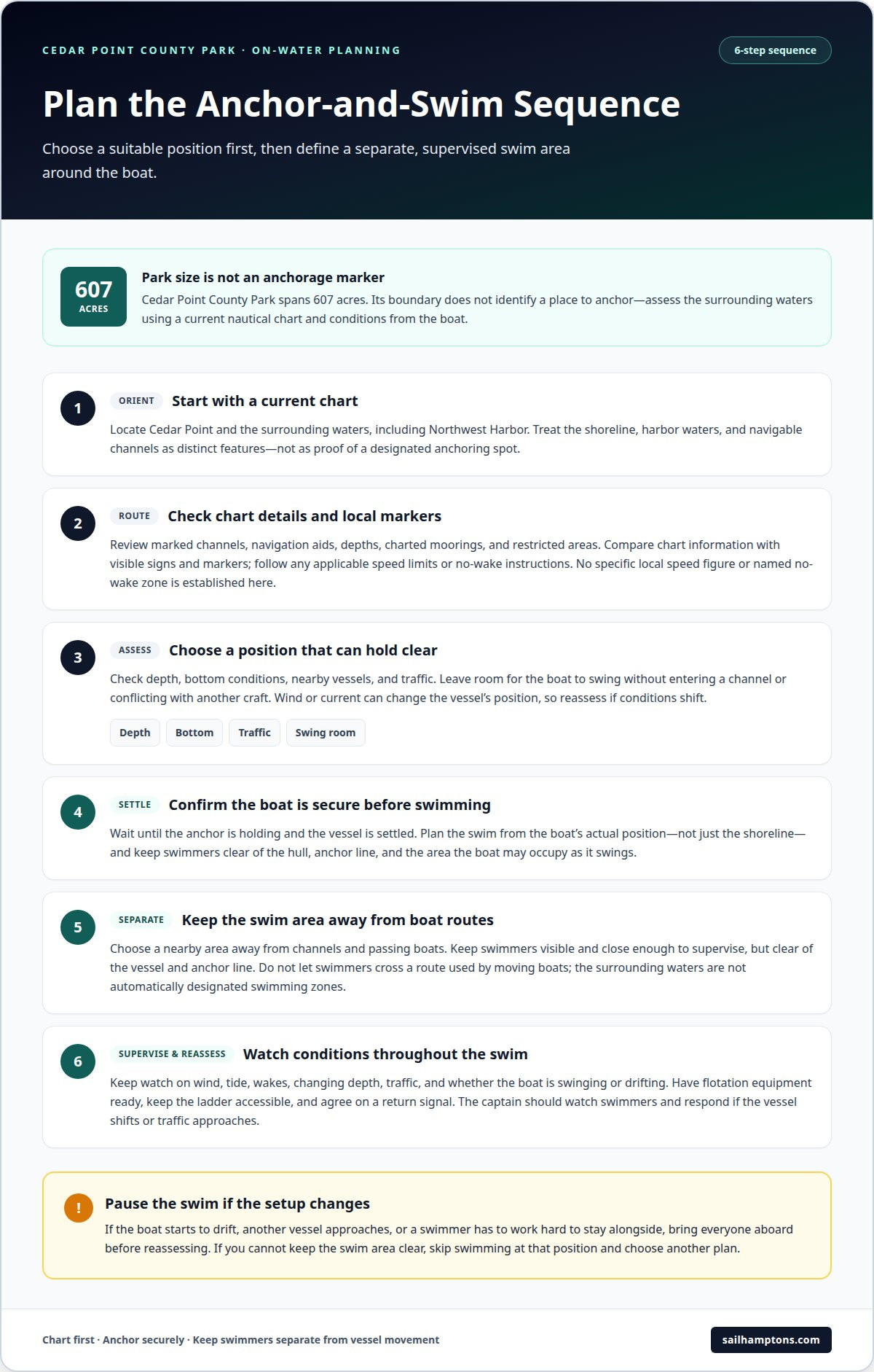
Cedar Point County Park in East Hampton, New York, covers 607 acres, according to Suffolk County Department of Parks, Recreation and Conservation. That figure describes the park, not a place to anchor. The shoreline, nearby harbor waters, and navigable channels are distinct features. For a visit, identify Cedar Point on a current nautical chart, then assess the surrounding water rather than treating the park boundary as an anchorage marker.
Start with a current chart of the waters around Cedar Point and Northwest Harbor. Check marked channels, navigation aids, depths, charted moorings, and restricted areas before choosing where to anchor. A nearby beach or park access point does not, by itself, mark an anchoring area. Use the chart to plan your approach and avoid obstructing traffic or getting too close to shore.
Compare the chart with conditions from the boat. Check the depth sounder, look for nearby vessels, and consider whether the anchor can hold without the boat swinging into a channel or another craft. A spot that looks open on a screen may become unsuitable if wind or current changes the boat’s position. Leave room for traffic and keep swimmers clear of the vessel’s movement.
To anchor and swim at Cedar Point County Park, identify a suitable position in the surrounding waters rather than assuming there is an anchorage beside the park. Gardiners Bay and Northwest Harbor help orient you, but neither name identifies a specific anchoring spot. Check current charts, depth, bottom conditions, and traffic. If these do not support a stable, clear setup, choose another position instead of anchoring close to shore by assumption.
Are boat anchoring and swimming allowed at the same time or in separate zones?
Treat the anchored boat and swimmers as separate activity areas. Do not assume an anchoring position is also a designated swimming zone. Keep swimmers clear of the hull, anchor line, and the area the boat may occupy as it swings. This reduces conflicts between people in the water and moving or anchored vessels.
Plan the swim around the boat’s actual position, not just the visible shoreline. Before anyone enters the water, confirm the anchor is holding and the vessel is settled. Choose a nearby swimming area away from channels and passing boats. The captain should be able to watch swimmers and respond if the vessel shifts or traffic approaches.
Northwest Harbor and Gardiners Bay describe the broader local waters, not specific swimming zones. Conditions and traffic vary by location. If another boat approaches or your vessel starts to drift, bring swimmers aboard before reassessing. Do not let swimmers cross a route used by moving boats.
A practical sequence is to choose the anchoring position first, then define the swim area from the boat. Keep swimmers close enough to supervise clearly, while leaving space around the hull and anchor line. Have flotation equipment ready and agree on a simple signal to return aboard. This helps everyone coordinate without treating unmarked water as a designated bathing area.
Plan for anchoring and swimming during the same outing, but in separate spaces. The distance between them depends on the boat’s movement, nearby traffic, and water conditions. If you cannot keep the swim area clear, skip swimming at that position and choose another plan.
Are there speed limits, no-wake zones, or other boating rules near Cedar Point?
Near Cedar Point, use current nautical charts and on-water markers to identify applicable speed limits, no-wake areas, and navigation channels. The available local facts don’t establish a specific speed figure or a named no-wake zone, so don’t assume one limit applies throughout Northwest Harbor and Gardiners Bay. Restrictions can vary by location, and posted signs or markers help identify where they apply.
Before setting out, review your route on a current chart and note marked channels, navigation aids, and restriction symbols. As you approach Cedar Point, compare chart details with visible signs and markers. Follow the instructions for the waters you are entering instead of relying on expectations from another harbor or shoreline.
Speed matters when passing swimmers, anchored vessels, and smaller craft. Reduce speed early if visibility is limited, traffic gathers, or your wake could affect nearby boats. A comfortable cruising pace in open water may be unsuitable near a narrow channel or anchored vessels. Keep watch, leave room to maneuver, and avoid crossing another boat’s path.
For a careful approach, confirm the charted route, watch for local markers, and adjust speed to traffic and conditions. Where a sign indicates a no-wake area, proceed slowly enough to avoid creating a wake. If a chart symbol is unclear, pause in safe water and consult a current chart or local navigation notice before continuing.
These habits help you reach an anchoring area without surprising other boaters or disturbing people in the water. Around Cedar Point, follow the instructions for each marked stretch and keep your speed and wake considerate of nearby vessels. A calm approach makes it easier to position the boat and plan your outing.
What are the water conditions, currents, and hazards for swimmers and anchored boats
Near Cedar Point, wind, tide, vessel traffic, and shoreline shape can affect both swimmers and an anchored boat. Before anyone enters the water, observe the surface and check whether the boat is swinging, drifting, or riding steadily. A change in wind can alter its direction even if the anchor initially holds.
Currents matter when swimmers move away from the boat or toward shore. Choose a nearby area where the group remains visible, and avoid crossing a channel or another vessel’s path. If a swimmer has to work hard to stay alongside the boat, bring everyone aboard and reassess. Keep the ladder accessible and agree on a return signal before swimming begins.
Watch for wakes, changing depth, and underwater features near shore. A passing boat can move an anchored vessel, while shallow water may limit where it can safely settle. Use the depth sounder and chart together, and keep swimmers clear of the anchor line, which can be easy to overlook when attention shifts to nearby traffic.
Water quality and lifeguard coverage are separate from conditions around an anchored boat. At Cedar Point State Park, swimming may be prohibited if lifeguard coverage or water quality compromises swimmer safety. This rule concerns the state park, not conditions at Cedar Point County Park. At either location, follow posted instructions and consider current conditions before swimming.
Before swimming, pause for a simple check: inspect the water, watch the boat’s movement, identify nearby traffic, and keep the group together. If wind or current makes those steps difficult, stay aboard. For a more composed day on the water, explore a guided water experience.
SailHamptons
SailHamptons offers a hosted way to enjoy time on the water when you’d rather leave the sailing to a professional crew. Its private charter options include Luna Private Charter, Cosmos Private Charter, and Blue Sky Private Charter, while the Public Sunset Sail offers a shared sailing experience. Each provides a different setting for taking in the East End’s coastal scenery, without making an anchoring-and-swimming plan the focus of your day.
Consider a charter if you want a crewed outing instead of managing your own boat, or if a sunset sail suits your plans better than a swim stop. The right option depends on how you want to spend your time afloat. Contact SailHamptons to discuss a private charter or the Public Sunset Sail.
Set Your Next Day on the Water in Motion
Let the kind of day you want guide your plans. If you’re planning to anchor and swim at Cedar Point County Park, leave room to adapt to conditions and the group’s comfort. You might enjoy a quiet stretch afloat, swim when conditions are suitable, or choose a sailing outing focused on the scenery.
SailHamptons offers Luna Private Charter, Cosmos Private Charter, and Public Sunset Sail for different ways to enjoy the water. A private charter or shared sunset sail can suit you if you would rather experience a hosted sailing outing than manage your own anchoring plans. Choose the style that fits your occasion, and contact SailHamptons to plan your day.
Ready to explore an outing on the water? Contact SailHamptons to discuss your plans and find a fitting next step. The East End is waiting.
Frequently Asked Questions
Can you anchor a boat at Cedar Point County Park in East Hampton, NY?
Anchoring happens in the surrounding waters, not within Cedar Point County Park’s land. For an outing to anchor and swim at Cedar Point County Park, use a current nautical chart to choose a suitable position and avoid marked channels or restricted areas. The park’s address is 5 Cedar Point Road, East Hampton, New York 11937, which helps distinguish the East Hampton location from other parks with similar names.
Is swimming allowed at Cedar Point County Park, and where?
The scheduled swimming beach is at Cedar Point State Park, a different destination from Cedar Point County Park. Its 2026 swimming season runs June 27 through September 6, with the beach open daily from 10 a.m. to 6 p.m. Swimming may be prohibited if lifeguard coverage or water quality compromises safety. Don’t assume the State Park’s beach schedule applies to the County Park shoreline.
What are the park hours, seasonal dates, and boat access rules?
Cedar Point State Park is open from early May through Columbus Day. Its 2026 camping and cabin season runs May 1 through October 11, while its boat rental season runs May 2 through October 11. These dates apply to the State Park, not automatically to Cedar Point County Park. At the County Park, vehicular access to the outer beach requires a permit.
Are lifeguards, restrooms, boat ramps, or moorings available at Cedar Point County Park?
Cedar Point State Park’s swimming information notes that swimming may be prohibited when lifeguard coverage or water quality compromises safety. This does not establish lifeguard availability at Cedar Point County Park. Treat restrooms, boat ramps, and moorings as location-specific amenities rather than shared facilities. Plan separately for County Park land access and State Park boat access.